Geography
Saudi Arabia spreads across 80% of the Arabian Peninsula, bordered by the Red Sea and the Gulf of Aqaba to the west and the Persian Gulf to the east. A harsh desert climate means its summer days are dry and hot, and its summer nights are cool. In winter, temperatures are mild. Sand and dust storms abound, and sometimes rain can cause flooding.
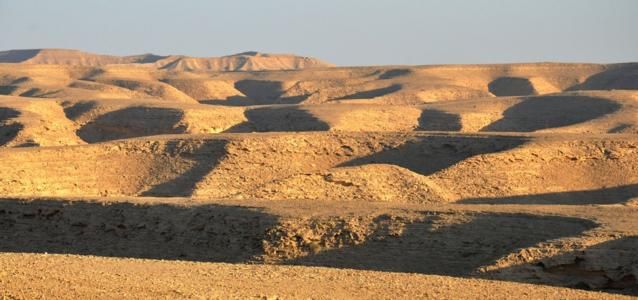
Arid and barren by nature, the desert is nonetheless dotted with oases and ancient riverbeds where valleys (wadis) can briefly turn green after an hour of rain. Today in some small areas across the landscape, the desert has made way for lush agricultural land, thanks to advances in underground water extraction and desalination technologies.
The central part of Saudi is a plateau region that starts as a mountainous range in the west and extends towards the east and Riyadh, where it becomes the Tuwaiq Escarpment.
This is the canyon land of the kingdom, a long steep cliff edge that runs from the city of Buraydah in the north, all the way to the edge of the Rub’ Al-Khali.From soft, light sands that build up into sand dunes to rocky barren terrain, the Saudi desert is both highly habitable in areas and uninhabitable in others.
The Empty Quarter
The Rub’ al Khali (or Empty Quarter) is a large stretch of sand that cuts across an inhabited area in the southern end of the peninsula. It was totally unexplored until recently. Of course, ‘uninhabited’ does not include the Bedouin tribes and their camels who continue to criss-cross it in search of water all year round!
For perspective, the Rub’ Al Khali has summer temperatures of over 61°C (142° F) in the shade.
Along the western stretch of the peninsula is a range of mountains in the Asir Province: the ‘Alps of Arabia’. Okay, not so much Alps but rugged mountains, some of which have peaks that reach 2700 meters. With 20 inches of rain every year, this is Saudi Arabia’s most fertile region, its agricultural heartland.
Photo credits: Blue Abaya Photography